
A Warminster Skyline Walk
- Glyn Coy
- Aug 5, 2020
- 4 min read

Updated: Aug 5, 2020
The hills around Warminster sit on the edge of the wide expanse of Salisbury Plain and contain an incredible amount of history. While both Battlesbury and Scratchbury hills contain impressive Iron Age hillfort ramparts, there is evidence dating back to the Bronze Age, and through to the Roman period.
While I have visited each of the hills independently I mapped this walk out to take in the whole landscape in one day. It is just over 4 miles, but it is a strenuous set of miles as you ascend and descend 3 hills so it is best to allow a couple of hours, more if you want to have rest stops and take photos.
The walk begins just off Battlesbury Road, which is accessed from the Imber Road. You turn right once you have gone past the Waterloo Lines army base and before the road turns into Sack Hill. A few hundred metres down the road is a left hand turn onto a wide concrete tank track where you will normally see several cars parked as others take a walk in the hills.
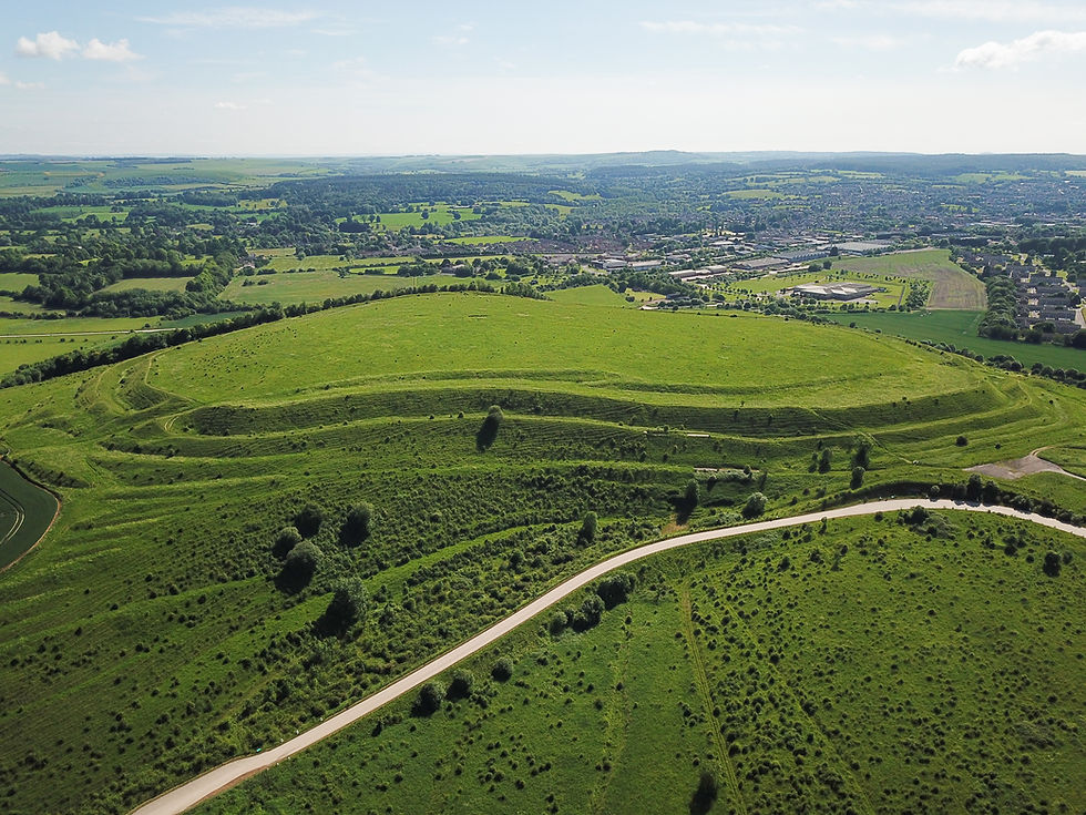
A footpath will take you straight ahead towards Battlesbury Hill. I wouldn't recommend the visible track that takes you straight up the front of it, although I have seen military folks running up it as part of some masochistic exercise routine. The right of way takes you left and diagonally up the hill on a more leisurely incline. As you hit the top of the track you will see an entrance to the hillfort with imposing Iron Age ramparts to the left and right. At this point you will go right, and follow the ramparts around until you meet the fort exit, marked by a metal star on a pole that stands atop a high part of the rampart. Taking in the views here will reward you with the sight of Oxendean Down and some impressive strip lynchets in front of Bigbury Wood.

Up on the ramparts you might have noticed a wooden bench, which has been put there to commemorate some young soldiers who were sadly killed in a bomb explosion in Afghanistan. Many of them were from the Yorkshire Regiment, and the bench overlooks their garrison below. Views from this bench also take in Cley Hill in the distance, which is another Iron Age hillfort.


But after taking in the magnificent Battlesbury Camp hillfort we start our descent and head east towards Middle Hill. As you look across at the next hill, note the prominent strip lynchets of the left side. These are terraces which are thought to be remains of medieval agriculture and this hill contains some of the finest examples of lynchets in the county. Crossing a field below we eventually hit the concrete tank track again, and turn right before following the footpath sign left, and head up the steep track to the summit of Middle Hill. While the hill is dwarfed by its more prominent neighbours, it does contain a prominent bowl barrow on the top which is covered in trees, and well worth a look.

Descending down the hill will bring you to a small parking area, and here you will join the road leading to North Farm. A footpath sign will point you right so you can head up Scratchbury Hill. At the entrance gate you can choose your own way. Straight on will lead you on a steep trajectory up and over the summit. Personally, I always go left and follow the ramparts all the way around the hill before exiting at the same place. Take your time to explore as much as you can, and note the many Bronze Age barrows dotted around the hill. As you do so you might notice that there is an inner enclosure on the hill, which is thought to be Bronze Age, with the outer ramparts that shape the hill dating to the Iron Age. So much history in one place.

I must confess that Scratchbury Camp is my favourite hillfort to wander around. It is a little more remote than its neighbours, which means you can often find yourself alone up there, imagining how the ancient people would have occupied this space. From the south side of the hill the views are extensive. You can see the steeple of St John's Church in Sutton Veny, and the circular shape of the gallops at the foot of Cow Down. Looking further into the distance you can make out the hills on either side of the Deverills, with the long barrow near the summit of Cold Kitchen Hill clearly visible. I will never tire of these views.


Another thing worthy of note is the connection to the poet, Siegfried Sassoon who spent much of his life living in nearby Heytesbury. He wrote a poem entitled "On Scratchbury Camp"

When the time comes to leave Scratchbury, you retrace your steps to Middle Hill. Instead of heading back to the barrow, follow the path left, and you will see a path crossing fields below Battlesbury Hill which will lead you back to your car.
One last thing to address a question that often comes up about my photographs in these parts. You will notice on this walk that there are several metal stars on top of poles. These indicate sites of archaeological significance, and let the military know not to drop bombs on these locations !


Comments