
A Prehistoric Landscape under Big Skies
- Paul Timlett
- Dec 14, 2025
- 12 min read

I have to confess that this is something of a lazy blog. I based this walk largely on one posted by Louise Powell on her Circular Wiltshire Walks Instagram page. I was trying to squeeze a walk in before Christmas and was struggling for inspiration. This is an area we’ve covered a couple of times before at Hidden Wiltshire and you will find links to earlier blogs below. But I wanted to focus more on the natural landscape and the prehistory in the area around the Ridgeway in this blog. For that reason this will be a slightly shorter blog as there were no churches or historic buildings to crawl over.
After a few rainy days my regular walking buddy Stu and I picked a rare dry day for this walk. The forecast promised warmish temperatures and a mostly bright sunny day. As you will see from the photographs the forecast could hardly have been more inaccurate.

We arrived at the Hackpen Hill car park on the Ridgeway in gloom. In fact as we drove up the A4361 from Avebury it looked as though we would be walking in cloud or mist all day but as we ascended the hill towards the Hackpen Hill White Horse the mist cleared a little to reveal a slate grey sky. Hardly ideal for photography. Climbing out of my car (Sid the Snot Wagon – anyone who’s seen it will understand) we were buffeted by a strong wind and freezing cold temperatures. As seasoned walkers we were both well prepared and were glad of all the layers we’d packed. After reading the several battered interpretation boards around the car park, and being careful to avoid the litter and dog poo everywhere, we crossed the road and began our journey south west along the Ridgeway.

A cursory look at the 1:25,000 Ordnance Survey map will reveal a proliferation of scheduled monuments along this stretch of the Ridgeway, with earthworks, enclosures, mounds and tumuli everywhere. The Historic England website offers very little information other than that these mostly date to the Bronze Age. As I’m sure our readers will know the Ridgeway is said to be the oldest “road” in Britain. I guess it’s no coincidence that so many prehistoric (and later) monuments are clustered here. The map also says that this section is also the route of the White Horse Trail. And it will also come as no surprise that it is also the Sarsen Way, although there was a distinct lack of pickled onions up here.
After a few minutes we soon encountered two of only three people we were to see all day (if you exclude a couple more we saw from a distance). I was already a little gloomy due to the weather and the state of the Hackpen Hill car park. Things went downhill when I saw a new Clipex fence being installed all along the eastern edge of the trail. I know it’s quick and easy to instal and lasts five times as long compared to wooden fence posts and stock netting but the aluminium seems so out of place in such a historic landscape. I’m not even sure why fencing is required at all as I’ve never seen livestock on that side of the trail. And don’t even get me started on the subject of barbed wire! But we came across two guys who were chain sawing their way through hawthorn and scrub in order to clear the way for further fencing.

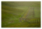
Before long we came to a byway on our right. The route takes us off the Ridgeway here in order to hold on to the views westwards. You can of course stay on the Ridgeway to save time but this stretch was muddy and the higher ground to the right of it means there are no views west. So we followed Louise’s recommendation and turned onto this short stretch of byway west.

Her route then takes you to the right through the metal pedestrian gate in the photograph below to follow the public right of way south along the escarpment. We also followed this but I would instead suggest following the farm track that runs parallel to it on the other side of the fence, also in the photograph below. The photograph on the left shows the gate and the one on the right shows the farm track on the other side of the fence where you can also see one of the many signs asking people to keep their dogs on a lead (fat chance) and giving information about rat control! That’s the route you should take and which I show on the route map.

Whilst this track is not a public right of way its use is permitted by the landowner. There are the aforementioned signs all along it and others stating that this is a private nature reserve. We saw a board that shared information about some of the wildlife you might see so the landowner is clearly happy for people to walk here. And the track is much easier going than the rough grass and steep hillside on the public right of way across Berwick Bassett Down where it would be easy to turn an ankle. The track passes Berwick Bassett Clump just after which the public right of way re-joins it by a disused pit but on opposite sides of a fence. By this point we had already walked across to the clump to join the farm track and we remained on this.

As you can see from the route map, the public right of way is right next to the farm track for a short stretch but on the other side of a fence. They then diverge for a short way where we continued on the farm track for about 100 metres. We then turned right at one of the signs (see photo) until we came to another sign saying “Private No Public Access or Right of Way”.

Behind us as we faced this was a metal pedestrian gate into a field. Go through this as it will take you through the fence to re-join the public right of way that crossed Berwick Bassett Down. You need to be on this side of the fence in order to take in the loop I have added to Louise Powell’s original route. This is a thoroughly worthwhile deviation.
The right of way descends the hillside quite steeply in a gully. On the lower slopes are a series of disused pits which I believe were clay pits. If you were to turn and head due east back up the hill all the way to the Ridgeway, at the junction (marked Pits (dis) on the OS map) Victorian maps show a Brick Yard here.

I have included an annotated screenshot of the route map which shows, amongst other things, where the brick yard was. (I’ve since changed the route shown in the screenshot a little so just focus on the annotations not the route itself.) I’ve no idea when the brick yard existed but we wondered whether the deeply worn gully from the bottom of the escarpment where the pits were was the route that the clay was carried for the manufacture of bricks? If anyone knows I would love to hear from you.

At the bottom of the hill we stopped for coffee amongst the trees. This copse seemed to be located in a bowl and again we wondered whether this was an old quarry. Suitably refreshed we continued through a gate which warned us that there were cows with calves in the field (there weren’t). We followed the line of beech trees along the contour line before swinging east and gradually upwards passing several Bronze Age burial mounds as we went.

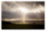
Here, on the lower slopes of Monkton Down, I shot a short video as we watched red kites circling and beyond the beginnings of a light display that will stay with me for as long as I live.
The dark clouds were scudding across the landscape over Pewsey Down in the distance. Great shafts of sunlight illuminated fields and clumps far away, specular rays casting themselves from the heavens above. As I stood marvelling at this spectacle, which continued for over half an hour, I imagined our ancestors standing in this place witnessing this same scene millennia ago. Is it any wonder this was such an auspicious place to bury their dead? There were burial mounds below us and above a whole barrow cemetery all facing the sacred landscape to the south, a landscape that contains the stone circle at Avebury, Silbury Hill, West Kennet and East Kennet long barrows and the Sanctuary. As I always think to myself in places of such antiquity, far more people lived here then than do now.

We eventually tore ourselves away from the light show and continued up the slope. At a fence line we looked down into a dry valley, a bottom. What we had previously thought were sheep were in fact sarsen stones.
This is exactly why they are also called Grey Wethers as people thought they looked like sheep. I took a rather poor photograph of the valley showing the stones and, in the distance, sheep. We followed a fence line along the edge of the Open Access Area containing the Grey Wethers close to which a large sarsen provided a nice foreground subject for a photograph of the continuing light show.

We soon re-joined the Ridgeway. Before turning south we headed along it for a 100 metres or so in the opposite direction to the place where the brick yard is shown on old maps (see my annotated map above). We were hoping to find evidence of it. We found a thicket containing a dew pond and some sarsens but little else so we retraced our steps and continued south.

It seemed scarcely possible but the illuminations had intensified and the dramatic light show was constantly changing, picking out features in the landscape to the south and west. I struggled to do the scene justice with my camera.
After around 500 metres we took the second public right of way on the left through a gate next to which stood a large sarsen stone to head east once more towards New Totterdown. I had planned on taking another detour into Totterdown Wood as I knew a lot of work had been done recently to regenerate the woodland, but the daylight hours were brief and if we were to avoid walking in the dark we had to stay on the route. New Totterdown appears to have been a pair of cottages in the past but is clearly now one large much extended property nestling in the trees far from anywhere.

Beyond it to the south is the site for what one publication suggested was the location of the Preceptory of the Knights Templar, founded in 1155 but I’ve seen no other evidence for this. I would recommend that you read our Elaine Perkins’ blog about the Knights Templar presence in this area which I have linked below. Meanwhile I thought this remote location would be the perfect place to live. Stu simply said it was a long way to go if you run out of milk.

After New Totterdown the route crests the hill and continues ahead down what was now a farm track and public footpath towards Temple Farm and Temple Bottom. Again, Elaine describes this area in detail, but my attention was grabbed by a curious structure in the valley beside the track. Stu had his binoculars with him and thought it was a shooting lodge.

Eventually at the bottom of the track we came to Temple Farm itself, a substantial farmhouse nestling in the valley bottom. The right of way passes in front of it and heads west behind the barns before continuing along the valley bottom at the base of an escarpment – Rough Hill.

It then climbs towards the head of the valley in which a number of young trees had been planted and the sarsen stones clearly repositioned in a line leading up the valley. We thought the trees looked like olive trees and towards the end of our walk we noticed a sign by the road directing contractors towards the “olive tree project”. Curious.

At the head of the valley the right of way turns sharp right almost 180 degrees to head east. This section was very muddy as it had been used to move cattle. The track continues level over the crest of the hill before descending towards Wick Down Farm.

A couple of hundred metres before the farm buildings is the location of what was a Medieval farmstead, the predecessor to Wick Down Farm. The remains of this are clearly visible in the landscape and it is easy to make out the earthworks marking the position of farm buildings and enclosures.

Passing through the modern day farmyard we headed north, passing more earthworks on the farm track which serves as the road to the farm. Historic England makes no mention of these. Now as a child I can remember once seeing a white pheasant in my Aunt and Uncle’s garden near Winchester. I haven’t seen one since. Until today. We saw one in a field adjacent the road. Then we saw another, assuming it to be the same bird. But then we saw four, five, six and more. They were everywhere!
At a junction of farm roads we turned left along the road which is also a byway. Just after the belt of trees was a metal field gate. It was now about 2:30 pm and we hadn’t yet stopped for lunch. So we stood by the gate using the gate posts as table tops watching the red kites over the trees on the escarpment above and three herons in the adjacent field. It was then that we saw our third human being of the day. A farm worker approached on a quad bike drawing a trailer on which was mounted a bird feeder. He trailed bird seed as he went, heading up another farm track then along a field boundary. All of a sudden there were pheasants everywhere. We’d seen them all day but now there were hundreds.
So this is the part where I become a little controversial. In preparation for this walk I had been reading about this 2000 acre estate. Various publications talk about all the conservation work they have been doing, having planted 23 miles of hedgerow and a million trees, transforming an intensive arable farm into a profitable farm and wildlife haven with the assistance of grants from a number of bodies including the Government. It seems many wild birds have returned to the area and earlier in the day we had seen a flock of yellow hammer and a few corn bunting. But make no mistake, this landscape is focused almost entirely on shooting, and the landowner stated that his first priority was to create a pheasant shoot. There seemed to us to be very little agriculture apart from a handful of cattle and sheep. The whole landscape is set out for shooting. The hedgerows are laid out to allow pheasant to pass through between drives and there is covert everywhere. And of course many thousands of pheasants. The sheer number of red kites we saw, more than almost anywhere else I’ve been, probably reflects the amount of carrion available but also I guess the food distributed for the pheasants.
Now I know farmers have to make a profit. Of course they do. But is this farming? I could see little evidence of food production unless that was elsewhere on the estate. And there was very little natural about this landscape. I certainly wouldn’t describe it as a nature reserve as the signs said. Yes we saw some wild birds (I’ve never seen such a large flock of yellow hammers) and a lot of red kites, and we saw a few hare. But my abiding memory is of the enormous number of pheasants bred to be shot.

I may be being unfair here. I am no farmer. I don’t have to deal with the harsh realities of farming life. Maybe I have an unrealistic idealised view of the countryside? The return of so many wild birds to what was apparently a sterile landscape is to be welcomed and the efforts of the estate to achieve this to be applauded. That has to be better than what came before or what might otherwise be had intensive arable farming continued. But I am left imagining what this land could look like and what it once looked like long ago, and I have seen what other landowners have achieved.
So continuing along the byway for nearly a kilometre we approached Fortnight Bungalow. When planning this walk I was curious as to what this might be but it was indeed a bungalow, surrounded by CCTV! I wonder what they did to warrant it being named on the OS map? But there was something curious in the garden. Stu whipped out his binoculars and lo and behold there were two horse sculptures crafted from fallen branches. From a distance they were very lifelike. What was even more curious the life-sized stone rhinoceros!

From Fortnight Bungalow the track climbed steeply through the oddly named Shoulder of Mutton Plantation (I have absolutely no idea where this name came from) to cross the road to Marlborough, once a turnpike road. The route continues past the gallops on Preshute Down to once again meet the Ridgeway.

Here we turned sharp left passing a copse that had the feel of Furze Knoll about it before returning to the car park. But before doing so I walked through and around the copse, finding a memorial to someone who had clearly had a troubled life – a much loved husband, brother, uncle and great uncle. From the edge of the copse I took a photograph of three horses grazing above the chalk White Horse in the rapidly approaching darkness.

My version of this walk was 10.7 kms/6.6 miles. It was mostly easy going with a couple of stiff climbs but it is muddy in places. Once you have passed beyond the dog walker zone by the car park keep your eyes on the sky. This is the memory I will keep with me long after I am no longer able to take to the hills.


Link to the route map in OS Maps