
Old Winsley, Turleigh and The Elbow
- Paul Timlett

- Feb 2, 2022
- 8 min read
Updated: Feb 20, 2023
Listeners to the podcast will have heard us talk about Sarah Lucas. Sarah moved from Wiltshire to Scotland some 30 years ago and is a keen follower of Hidden Wiltshire. She spent much of her early life living in Winsley and has fond memories of the area. She asked if we would do a walk there and take photographs of some of her favourite places. We were very happy to oblige. On a wet and windy January day Glyn and I met in Winsley where we were joined by another Hidden Wiltshire follower, Bo Novak. Bo knows the area well and agreed to show us around. We took the audio equipment with us and recorded some of our observations along the way as once again on a location recording we sought shelter from the strong wind and rain. We will feature this in an upcoming podcast.
Sarah told us that she had lived in a number of houses in Old Winsley, and that her grandparents had once owned a house called The Elbow overlooking the canal between Avoncliff and Murhill Wharf, so we chose a route that encompassed most of these places together with the lovely village of Turleigh. We had limited time on the day so had to leave out Avoncliff, although we had good views of it from above as we descended towards The Elbow. We parked on the road outside Burghope Manor, with some fields opposite, and began our walk.
Sarah told us some fabulous stories about Winsley. Her father was instrumental in turning the old primary school into the Social Club. The fact that it had a full sized billiard table and that he was the pre-war billiards champion of Wiltshire I’m sure had nothing to do with it! Her family once lived in Manor Cottages. One night in the 1980s the Manor House was burgled and a hoard of antiques was taken. Sarah’s father happened to be out of bed suffering a migraine and saw a van outside. Thinking nothing of it he went back to bed. When quizzed by the police about the van the next day he said that he hadn’t noticed the registration number. Undeterred Wiltshire Police called in a hypnotist from Cornwall who “put him under”. In his hypnotic state her father recalled enough of the number plate to enable the police to catch the culprits, and most of the antiques were recovered! The case was heard at the Old Bailey. In her gratitude the owner of The Manor at the time, Beatrice Knatchbull, gave Sarah’s father a large picture depicting an old cricket match. When I emailed Sarah to say we had completed the walk she had just been hanging the picture in her house in Scotland!
Our first stop on the walk was St Nicholas’ Church. The date of the first building here is unknown but the first surviving record of it seems to be from 1349. The tower is built in a style redolent of the 15th century, and a window in the chancel is possibly a remnant of a building of the 13th century. However the main building was changed substantially in the mid 19th century. The tower is clearly much older and has a number of stone panels above the door which have been worn away to the point where they are almost illegible. One of the photos shows the curious way the tower has been connected to the main building. I must admit the lighting in the main building took us all aback. It was like a boudoir and someone had clearly forgotten to put away the Christmas decorations as the nativity scene was still in place in front of the altar!


We spent some time wandering the narrow streets of Old Winsley. There are beautiful old cottages everywhere. And of course we found our way to The Seven Stars pub, although sadly there was no time to go in. Next time – Bo assured us it would be worth it.

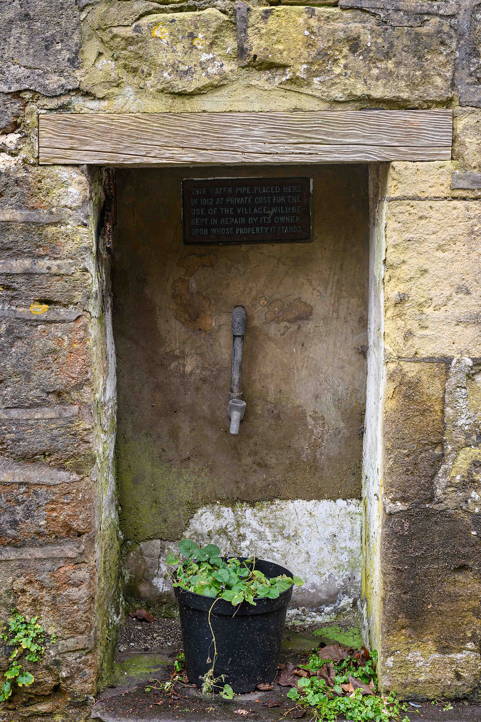
From the pub we headed back in the direction of the church and went round a sharp right hand bend in the direction of the war memorial and we soon came to the steep lane towards Turleigh. After a little way we came to the spring which emerges from behind a little metal gate in the wall at the side of the lane. The water is crystal clear as it emerges, so much so that Bo filled her drinking bottle. She is either very trusting or has a cast iron stomach! The water flows directly into what are known as the Turleigh Troughs or Trows, a series of interconnected basins cut from stone which some say were the coffins of children. They certainly look like it. This was once the source of drinking water for the hamlet and fed some of the richer households which were later connected by pipe to the spring. A little further down the lane, past Turleigh Manor, we came across a little niche in the wall of a house with a water pipe. A plaque said it was placed in 1912 at private cost for the use of the village. Someone has nobbled the tap though!

Many of the houses in Old Winsley and Turleigh provide clues as to how self-sufficient it was as a community. There were several old brewhouses, the old post office, tannery, bakehouse and so on. All those businesses have gone and the buildings turned into chocolate box cottages. Clearly it’s a desirable place to live as someone had posted a card on the door of the old phone box in Turleigh (now the village library) seeking a house to buy in the hamlet. Money appeared to be no object.
Turleigh Manor is a fine looking house on the junction facing up the hill in the direction we planned to head. It was built in about 1700 for clothier John Curll and his wife Querina. Now there’s a name to conjure with! Behind it in the garden was an equally fine looking private chapel. Just down the hill from The Manor was an unusual house squeezed between two lanes. If you look carefully at the photograph you’ll see the external walls are not at right angles. It reminded me of the Flatiron Building in New York.


Back at The Manor we walked up the hill along Green Lane where the views opened up behind us of Turleigh and the lane to Bradford-on-Avon. At the top we turned right to head down a track towards the canal with views of Avoncliff and Westwood below. You can make out the Cross Guns pub in the photograph, to the left of which is the tall chimney with a slight kink in it which we were told later is called the Zipper by the locals. You can see why. This is the chimney from the old woollen mill. To the right of the pub can just be seen the aqueduct carrying the Kennet and Avon Canal. The stone came from the quarries at Winsley and apparently some of the poorer quality stone was used in part which resulted in one of the arches developing a sag. To the right of this, but out of shot, is what used to be the Poor House.

As we strolled down the track towards the canal Bo asked where The Elbow was - the house we were supposed to be looking for. I had to admit I had completely forgotten about it, but we were approaching a solitary house standing alone in the meadow overlooking the canal and onwards to Freshford Station. I looked at the map and realised this must be it. A few metres further on a gate post bore the name The Elbow and the numbers 51 and 51A (I think that’s right).


At the bridge we remained on the same side of the canal as The Elbow and walked along the narrow towpath heading north-west towards Murhill Wharf. The wider, safer towpath is on the other side of the canal but we would have been on the wrong side for the walk.
Murhill Wharf was built to serve the quarry in the hill above. In 1826 a tramway was constructed connecting the wharf up the very steep hill to the quarry. Rails from tramway can still be seen poking through the surface of the lung busting track up to lane above. A balanced incline system was used to lower wagons laden with stone down to the wharf where it was loaded onto barges. Working like a clock pendulum the empty wagons would have been lifted up the incline on a parallel rail by the weight of the laden wagon coming down.


Once up at the lane (some idiot had to go back down to the wharf as he forgot to take photographs!) where the hill flattens out for a moment we reached the quarry face and the mines dug deep into the hillside. We could see two outlet pipes used to drain the mines but somewhere along the hillside is the old boiler house used to fire the steam engine that powered the stone cutting plant. These quarries were an important source of stone, some of which was used for the facia of Bristol’s Temple Meads station and for buildings as far away as London, as well as for local walls and houses.


We tracked our way diagonally uphill through the wood taking what Bo described as the low road rather than the high road. Above we could make out Avonpark Retirement Home, which was once a TB clinic. Sarah told me her mother worked there as a nurse. She has a picture of her mother with several other nurses staring into a crater in the grounds of the hospital left by a stray bomb from a German aircraft. We came across the famed dragon by the path in the woods just before we came to a mixture of dry stone walls. People have been building these walls in the woods since at least 1918 and an initiative means they continue to do so today. Emerging from the wood we entered Murhill Bank Nature Reserve from where we headed back to the cars.


However, there was one final twist in the tale. The right of way crosses the car park at the front of Avonpark. On the far side and across a field there are a series of cottages built from local stone. We got chatting to a guy who was in his driveway doing jobs! He turned out to be an absolute encyclopaedia of knowledge about the history of the quarries. What followed was a long history lesson for us. As an architect he was very interested in the quarry and the stone. The quarries here and the wider area once employed thousands of people.He told us about the Zipper and the Poor House in Avoncliff, the balanced incline up from the wharf and the various caves cut into the hillside. He also gave us suggestions for a myriad of other sites we should see. Another time. I’m just hoping we picked up some of what he said on the mics we were wearing as Glyn was still recording. But by way of perfect symmetry to the day, and serendipity, he told us that a friend of his rented the annexe at The Elbow. His landlord must be Mr Griffiths.
Instead of providing an OS map for the route we took I’ve included a link to the walk that we initially intended to do that would take in Avoncliff, because you won't have Bo with you! Thanks to Miles Without Smiles for this route. Hopefully the weather will treat you more kindly.


Comments