
Langley Wood: The New Forest in Wiltshire
- Paul Timlett

- Oct 19, 2025
- 14 min read
Updated: Oct 20, 2025

I very nearly didn’t write this blog for reasons that will become apparent. I’ve long intended to visit the New Forest in autumn but since it is mostly in Hampshire my commitment to writing for Hidden Wiltshire meant it was always on the back burner. But then it dawned on me that part of the Forest does just creep into Wiltshire. Since Langley Wood is in part or entirely (I’m unclear which) a Natural England National Nature Reserve I should really have known that as I have been, until recently, a Natural England volunteer in Wiltshire for eight years. So on a grey mizzly October morning my neighbour and fellow Natural England volunteer Stu set off towards the Hampshire border.
The days have been grey but dry for weeks so to be met by a band of fine rain south of Salisbury was something of a shock. It certainly wasn’t forecast. Clear blue skies are not great for woodland photography. Rainfall intensifies and saturates the colours but I had hoped for a hint of brightness or even sunny spells. We were to get neither.
I’d spent some time trying to piece together a walk in Langley Wood but the public rights of way seemed to make a circular walk of any manageable length impossible. I did multiple internet searches for a route but drew a blank. The nearest I got was a New Forest National Park Authority walk which skirted the wood. So I decided to use this as a basis for a longer walk, adding an extension into Langley Wood itself. Here is a link to the New Forest National Park Authority leaflet describing their route should you want something shorter than the route we did.

As recommended by NFNPA we parked by Landford Village Hall on the B3079 Lyndhurst Road. Turning south from the car park there is a narrow pavement next to the fast, busy road but this fizzled out after the bus stop opposite the Methodist Church. The NFNPA route instructions suggest there is a footpath that avoids the road but this is not on the Ordnance Survey map and we certainly didn’t see it. So once the pavement finished we had to walk in the road for about 50 metres. But we soon found the long track on the right that continues westwards towards Hamptworth beneath a canopy of trees with arable fields either side.

To the left was something I’ve never seen before. A gangmaster directing a group of workers who seemed to be cutting down maize stalks, the crop long since having been harvested. On our right was a large field of pumpkins. This all had the feel of rural America about it.

At some length we reached the ford mentioned in the leaflet. As it describes there is indeed a small wooden bridge through a gap in the hedgerow to the right of the ford, or you can pass by on the left bank of the ford.

This led us to a minor road where we turned left passing the delightful little Old Chapel House as we went, before taking the footpath to our right after the junction.

This path joined the road from Hamptworth where we squeezed past a metal field gate to reach the road, the official footpath being impassible to anyone but Stick Man. Here we turned left to pass Hamptworth Farm, a lovely 17th century thatched house with a couple of equally attractive cottages beside it, before we came to what looked like a forest track on the right heading out towards the fairways of Hamptworth Golf Club, crossing the River Blackwater by a small bridge as we went. This was the last time we were to see a road for several hours, and we were quite happy about that.

The golf club was to appear several times on this section of the walk as we wended our way through woods with the fairways either side. I’m not a golfist but Stu reckoned it looked like a nice course. The autumn colours certainly made it look very attractive. But for me golf is just a good walk ruined.

As we continued along the track that rose and fell as it went we were starting to get an autumnal feel due to the colours in the trees. Eventually the track did a U-turn to the right by Whitterns Hill Farm and it was at this point that we said farewell to the NFNPA route for some considerable time as we entered Langley Wood by Gate 4. The Natural England interpretation board beyond the gate provided a brief introduction to the wood as we entered. But this was to be the start of what was to prove a very confusing few hours!


I failed to find any detailed history of Langley Wood, although I assume since it is on the northern fringes of the New Forest that it formed part of King William’s 11th century royal hunting forest. I did manage to find a little about the more recent history on the Redlynch Parish Council website which I’ve quoted below:
“The NNR has a complex history. Langley Wood itself was a complex system of periodically grazed coppices and the permanently grazed ‘Out Wood’, which is likely to have originated from establishing enclosed coppice coupes from unenclosed wood pasture in earlier centuries. Its functioning was described in 1678, when there were seven coppices and the permanently open Out Wood. In the 18th Century Langley Wood contained a remarkable collection of ancient Oaks.”
“In 1844 there were 12 copses and still rights of common for cattle and hogs through the year, in the parts of the wood which were yearly open. At this time one part of Apsey Copse, Upper Apsey, was permanently added to the Out Wood.”
“In 1876, the Out Wood was still clearly a grazed pasture woodland and latter maps through to the 1930s show that parts of it remained open up to at least this time. Other areas of common shown in 1807 within the NNR, were enclosed and converted to other land uses. In particular much of the floodplain of the Black Water and Moor Copse were also open land in 1807. North of the river within Langley Wood was part of the Out Wood, with the letting name The Lawns. South of the river, the open land was part of the common land of Downton, which was enclosed in 1822. The 1807 map indicates that this area was partly pasture woodland but no relic of this survives.”

Now as far as I was aware Natural England National Nature Reserves are mostly open access areas, meaning that you can walk anywhere unless there are clear signs to the contrary (eg a CROW Act Exemption). Equally the OS map suggests Langley Wood is part of the New Forest National Park where again we thought you could walk anywhere in woodland or heathland (obviously not, for example, in private gardens). The sign asked that visitors keep to waymarked paths to help conservation efforts and during the course of the walk we were to see a few signposted paths, but the circular path also shown on the interpretation board only seemed to exist in parts. As we were to find later it seemed to head north out of the wood and in completely the opposite direction to the way we needed to go.

We were able to follow the gravel circular path much of the way but unless we wanted to be led out of the wood we had no choice but to divert onto some of the many paths marked as a line of dashes on the OS map like this “-------". In almost every case these were well used paths which, we were told later, local people use all the time. I used a combination of the signposted paths and forest paths when plotting the route on the map at the end of this blog. But by way of a disclaimer, whilst it may be the habit of local people to use these paths, they may not be legal rights of way hence my deliberating as to whether to write this blog at all.

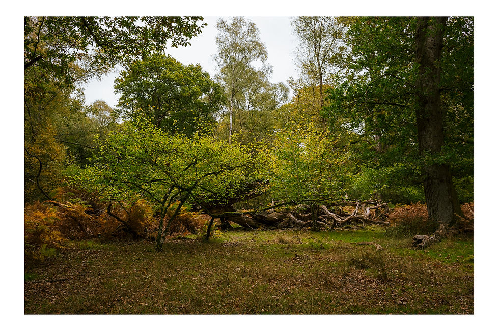
As we followed the gravel path, the autumn colours really began to reveal themselves. The bracken was a beautiful copper colour and many of the trees were starting to turn, each species reflecting the season at their own pace – some still green, some glowing yellow and orange. We also came across many species of fungi and I’ve included a small selection of photographs here. Apparently there are 600 species in the wood.


We soon found a wooden bridge by which there was a conveniently placed log for us to stop for a coffee. Whilst we could just hear the hum of traffic on the distant A36 the peace was all encompassing, interrupted only by the rustle of leaves and the plop of acorns or chestnuts falling from the trees as the wind picked up from time to time.

There was remarkably little bird song although the Merlin app we both have on our phones picked up and we saw Goldfinch, Siskin, Goldcrest and Robin. Stu wondered if there was a Goshawk about. It was the right time of year although they tend to remain silent until around February. Soon after I spotted just for a second a large raptor fly effortlessly between the branches, and I’m as certain as I can be that this was a Goshawk. Such a magnificent and well adapted bird of prey. A lethal predator. We were told later that they are present in the wood at this time of year.
Continuing along the gravel path we came to the point where my route took a turn to the right and away from the circular path. But this route was barred by a field gate. It bore a Natural England sign saying “Cattle” but nothing more. However, we decided to be cautious and continue along the signposted circular path instead. This took us in a long loop to the west and north before apparently leaving the wood. This was no use to us at all but we could see from the map that it joined a forest track which we hoped might lead us back in the right direction. However, when we reached it the track marked on the map did not exist and its direction was blocked by a fence with a sign saying “Private Property”. So we returned on the long slog back to the gate and my original planned route, having wasted half an hour.

Back at the gate we could see a well-worn path beyond so we took the decision to climb over the gate and follow the path. It was delightful section of the wood and we followed a fence to our right which bounded an enclosure. Whilst we saw no cattle we did see a small number of cowpats so they obviously do graze here from time-to-time. The cattle’s job is to keep the understorey of the wood clear to enable light to penetrate and facilitate new growth. We assumed the fenced off enclosure was to enable other areas to develop more dense scrub resulting in the mixed woodland that once predominated. The fence was not high enough to keep deer out but we saw many other examples of deer fencing later, although no deer. And indeed this is the history of the land use in Langley Wood. Our fellow volunteers at Natural England until recently worked every Thursday to manage the wood, enabling light to reach the denser areas. The cattle are a relatively recent introduction all designed to return areas of Langley Wood to how it once looked. However, we saw few signs that the coppicing that was once prevalent throughout Langley Wood was being continued today. There was ample evidence of past coppicing, including the remnants of the banks and ditches which served as the boundaries of old coppice enclosures.

The fence line we followed soon turned sharp right to form another side of a square. We followed the path which at times became slightly less distinct. But the way forward was still obvious. The fence line turned right again to form a third side of the enclosure but the path headed straight on. Having wasted so much time following the circular path that led nowhere, it was now time for some lunch so we found another log on which to rest. We were even further now from the A36 and silence prevailed. There was a slight chill in the air but we had prepared with suitable clothing. We sat quietly, making the most of the tranquillity and the rich golden colours of autumn.
Reluctantly we packed our lunch away and followed the sometimes indistinct path and soon came to another field gate beyond which was a signpost indicating a permissive path crossing in front of us. Since permissive rights of way are not shown on Ordnance Survey maps I have no idea where it started or finished so it was not on the route I had plotted. Whilst writing this I looked more closely at my photograph of the map on the interpretation board and it seems that if we had continued on the gravel circular path instead of turning back earlier we may have come to this permissive path which perhaps enables a complete circuit of the wood. The reader may wish to try this for themselves and one day I may go back and check, in which case there will be an addendum to this blog.

Discovering the permissive path meant that we had to deviate from the route I had plotted. The route you see on the OS Map at the end follows the gravel permissive path until we came to a broad grassy track on our left by which there was a green Natural England sign with nothing written on it! We had no idea what it indicated but it was on my original plot so we decided to turn off the permissive path and follow this grassy track instead.

It led us through Homan’s Copse and crossed a small brook in which concrete blocks had been placed to ease crossing so presumably it was intended to be used. Soon after crossing the brook the path turned right just to the south of Bagfield Copse before turning right again heading south to meet the NFNPA route we had left hours before.

We found ourselves back on the golf course, to be welcomed by a cheery golfist loitering in the wood looking for his ball. He found one, but just not his. The path was confusing here. The public footpath seemed to go both through the trees and on the golf course, interspersed with a permissive path. It sounds confusing but either route took us the same way and were only a few metres apart. Our objective was North Common Farm. On leaving the golf course we crossed a track (also a public footpath) to an enormous gate in the deer fence behind which was a four way finger post. Our route was dead ahead to North Common Farm.


Just after the farmhouse we were so busy trying to sneak a look at this beautifully renovated building that we missed our next turn to the footpath in the hedgerow to the right just after the entrance to the house. Mistakenly we continued down the drive towards Northlands before realising our mistake, so we had to retrace our steps. As we stood by the signpost to the footpath a golf buggy appeared behind us and stopped. We assumed it was some angry landowner wanting to have a go at us for some unknown misdemeanour, before the driver hopped out and asked if we were lost. He turned out to be the new owner of North Common Farm and he couldn’t have been more friendly. A delightful chap who couldn’t seem to believe his luck in owning the house. He explained that he was a keen mountain biker and walker and was the first of several people to say that he used the many paths in Langley Wood that were not signed footpaths. Having urged us to stop in at The Cuckoo Inn pub, he pointed us towards the path we wanted and warned us about the new owners of Landford Lodge who had put “Private” signs everywhere. It appears they had been happy for people to stray onto the estate and visit the mini arboretum of rare species and ponds. But their trust had been betrayed by dog owners who allowed their dogs off the lead to rampage among the herd of rare breed sheep. From then on they were loathe to allow the public access to the estate.
Just before we crossed an old stone bridge over the River Blackwater we got a good view of Landford Lodge. A magnificent 18th century country house complete with mandatory lake, it dominates its surroundings. I wasn’t surprised to read that it was on the market for £12m in 2024! Inevitably its construction appears at least in part to have been financed on the back of slavery. And of course the identity of the new owner is not available to the public although I heard someone say later it is a family associated with Tata Steel. I’ve no idea whether that is accurate.

Following the track that crossed the river it climbed gradually before turning left where we came to a sign indicating that the path both went straight on and turned right! We had already decided we were going to stop for a pint in The Cuckoo so we took the most direct route through the large gate in the deer fencing. The NFNPA route sends you straight ahead.

We soon arrived at The Cuckoo. I’d only been vaguely aware of it before but never been in. I’m now regretting having wasted so many years by not doing so! A visit to The Cuckoo Inn is an experience to savour. It was much smaller than I expected and has some history having been built in the early 18th century. Inside it comes across as a simple local boozer but I understand the food is very good. But it’s definitely not the sort of gastro pub that predominates today. But what really makes it a truly great pub is the staff and the locals. If you have a fragile ego I would stay well away as you will be mocked mercilessly the moment you enter. We were not spared.

We spent a memorable and hilarious hour in The Cuckoo where the conversation covered everything including politics and religion. We heard and shared many stories and some of them may even have been true. I could have spent all day in there. I was just grateful that it was Stu’s turn to drive. So do yourself a favour and drop in. You could even start and finish the walk there as there are some parking spaces opposite the pub. The landlord might even let you park in the pub car park if you promise to stop for a pint or something to eat afterwards. Here’s a link to The Cuckoo’s website and a photograph of just two of the reprobates we fell in with!

From the pub it was a simple matter of crossing the road to the green and continuing along Lyburn Road back to the ford we passed many hours before, now on our left. From here we re-traced our steps back to Landford and the village hall.
Apart from the confusion over the accessibility of paths, we loved this walk. On the walk itself we only saw three people, and we saw nobody in Langley Wood at all – we had it to ourselves. I’ve provided two route options – the one we did (10.24 kms, 6.36 miles), and the shorter NFNPA route (7.56 kms, 4.7 miles). To be honest the NFNPA leaflet was confusing and seemed to bear little relationship to what we found on the ground. But they have loaded the route into the OS Maps app where you will also find my route. Whilst both Stu and I have the same phones and are on the same mobile network I struggled to get a signal in much of the wood so we had to use Stu’s much of the time, and he lost signal a couple of times. You can’t go wrong with an old fashioned map and compass though.
Finally, if you are concerned about straying from the circular path by following my route, my assumption is that the gravel path is the circular path shown on the Natural England interpretation board. But I cannot confirm this at the time of writing.


Comments