
The Temple of Aliens
- Paul Timlett

- Mar 1
- 13 min read

There isn’t much hidden about Cley Hill. How many people travel past it every day and gaze up at this peculiar lump of a hill. Or maybe they don’t look at it all as it’s so familiar. I must admit every time I’ve driven past it I’ve thought that I really must go up there one day. So on this walk I had the opportunity to do just that.
However, that wasn’t the objective of this walk. Glyn wrote a short blog about Cley Hill with some aerial photographs back in 2018 (linked below). For us it was just a convenient place to park. A while ago my neighbour and walking buddy Stu chanced upon a delightful YouTube channel called The Salisbury Organist. The guy behind it is Ben Maton. He studied music at Oxford and is an accomplished church organist. In his videos he travels across Wiltshire and beyond visiting old churches where he sets out to play the church organ. These organs are in various states of repair – some of them almost unplayable. But Ben is a gifted musician and somehow manages to tease beautiful music from these old instruments. However, his videos are not just about the music. They are about the history and the countryside that provide the setting for so many wonderful churches. His gentle approach, soothing voice and sublime camera work provide 30 minutes or so of tranquil escapism. Here is a link to his channel:
So on this walk we set out to visit a church that Ben featured in a recent video. I used a walk from Country Walking Magazine that I found on the OS Maps app as the basis for our day out. The hamlet in which the church sits is tucked away in the folds of the landscape near Longleat, the church squeezed into a small depression off a narrow lane. I had no idea it was there until I saw Ben’s video. I’d certainly seen the little sign to the village on the A362 to Frome many times and often wondered what was down the single track lane. Today we were going to find out. But as with anything worth doing anticipation is all so our walk was to take us several kilometres through the landscape before visiting the church towards the end.

Of course Cley Hill is famous for being a mystical place, rumoured to be frequented by aliens. Long term Hidden Wiltshire follower and contributor Steve Dewey has written books about it. And right on cue as we left the little National Trust car park by the A362 to begin our walk, we were joined by the chap in my photograph. But as we branched right along the Mid Wilts Way at the start of our 10 kilometre circumnavigation of the hill, he continued on to make the climb straight up the southern slopes of the hill.

Our route was to take us along a tree covered hollow way. After what feels like months of rain it was pretty muddy but not bad enough for wellies. We began to wish that we had postponed the walk for a week or so as this stretch was about to become a carpet of wild flowers with daffodils, anemone and primroses emerging everywhere.

As we exited the trees we had a view of Cley Hill and there was our friend on the summit, arms out stretched with staff in one hand…. and selfie stick in the other. Stu had his binoculars and could see that he was making a video.

This section of the walk along the Mid Wilts Way follows the edge of a huge arable field (in the middle of which someone was walking her dogs!) and was quite dull, not helped by what had begun as a grey overcast day and the noise from the A36. As the route swung left then left again we got a good view of the two distinct humps that make up Cley Hill and which gave rise to the traditional rhyme:
Big Cley Hill do wear a hat
Little Cley Hill do laugh at that

We were now heading north west along the edge of Norridge Wood (once common pasture but now strictly private as the signs warned us) towards Cley Hill Farm with its backdrop of the hill, the sound of the A36 now receding albeit ever present in the distance.

Further on, between the track and the wood at Trussenhayes (from the old English “haeg” meaning woodland inclosure), was what looked like a glamping site with a number of pods behind the trees. It looked like the perfect spot for a peaceful few days.

The track twisted and turned, climbed and descended until we reached Water Farm where a planning application notice announced that the two barns would be turned into residential accommodation. A delightfully secluded location for a house.


Soon we reached a junction with the lane leading up to Corsley. We stopped to admire the Old Rectory on the corner, built in the early 18th century and the 1840s the mortar had been beautifully re-pointed which made it look much newer. It seemed to be shut up but there was a car and a van on the drive and who we assumed was the gardener strimming the drive.

From here you could just walk the couple of hundred metres left along the road to the church at Corsley but we took the public footpath across the fields just before junction. And we were glad we did, despite the mud. A small brook babbled and flowed beneath an old stone bridge, Divers Bridge, and would have been an idyllic spot had it not been for the water treatment works that was discharging something into the stream! Here we stood for a while listening to the loud and complex song of a song thrush answered by a robin close by but well hidden in the trees where we crossed the stream. Eventually we caught sight of it as it flitted from one tree to another secreting itself amongst the branches just metres from where we stood.
We continued on across the meadow up towards the church in the trees above, passing through a gate into the church yard where we planned to stop for coffee.
Corsley is not much more than a hamlet through which passes two quiet lanes. As we approached we could hear the sound of children playing in the playground of the little school on the edge of the village. Opposite the churchyard is the Old School House. Built in 1847 it looks like it is now a private dwelling.

The Church of St Margaret of Antioch is a grand affair which seemed out of place in such a small village. But built in 1833 on the site of a Medieval chapel it serves a wide ranging parish.

There are several monuments inside the church from the days before the current building which I’d love to show you. Apparently there is also a large marble commemorating local dignitary Nathaniel Barton who we were to encounter later on the walk. But the church was firmly locked. Regular readers of my blogs for Hidden Wiltshire will know how much that annoys me!

So we contented ourselves with a coffee on the bench outside the south wall admiring the daffodils and what looked like ancient tombs but in fact were no older than the 17th and 18th centuries. The sun was now emerging from behind the clouds and began to warm our old aching bones. We could have stayed in this peaceful little spot for the rest of the morning but we had to press on.
Before leaving Corsley we took a look at the delightful Manor Farm next to the church. The manor was built in about 1560 for Sir John Thynne, who was the steward to Edward Seymour, 1st Duke of Somerset (brother of Jane Seymour), and an MP. As we remarked, it’s almost impossible to escape the Seymours in Wiltshire! Thynne commissioned the building of Longleat House, and his descendants became Marquesses of Bath who occupy it to this day. The Manor was built or remodelled for him as a temporary home whilst Longleat House was being constructed. He occupied Manor Farm for five years during the rebuilding of Longleat after the fire of 1567. Longleat took 37 years to design and build in total due to the fastidiousness of Thynne. The gateway to the Manor in the photograph bears the lion rampant from the Thynne coat of arms.

Reluctantly we took our leave of the tranquillity of Corsley and passing what looked like a rubbish tip in a field entrance opposite Manor Farm we followed the field boundary, keeping the hedge to our right, towards Park Farm. We both loved the farmhouse.

So much more appealing than the huge intimidating country houses dotted about the landscape here with far fewer windows to clean. Ignoring the paths going left and right we continued ahead on the right of way through the farmyard passing the little greenhouse in the photograph, and what looked like a partially converted horse box to reach the gate in the corner. The sign at the back of the greenhouse and the colours caught my eye.

Once through the gate we crossed the meadow diagonally towards a house. We were aiming for Corsley House but that is not the house you see across the field before you. Corsley House is much larger and almost camouflaged on the other side of the road behind the house we could see. The colour of the stone of Corsley House made it blend into its surroundings but once on the road its grandeur became apparent.

The house was built in the mid/late 18th century and re-built in about 1820 for local lawyer and MP Nathaniel Barton (not the Disney character)! How do MPs end up owning such large houses I wonder? It is very likely that the same architect who designed the rebuilding of this house also designed the building of nearby Sturford Mead which we were to see later.

A gate led into the meadow to the south of Corsley House from where we could see the ha-ha which prevents livestock from entering the gardens. We could have just continued along the lane for the short distance to the A362 but we followed the footpath along the field edge so that we could get a view of the house.
The A362 can be very busy and despite the restricted speed limit most drivers seemed to ignore it. Extreme caution needs to be taken to cross the road to the gate opposite. When we did the walk the field through which the path passes was planted with beets but the farmer had left the right of way clear and obvious. Cley Hill once again dominated the skyline. Reaching the fence on the far side we got our first view of the village and the main objective of our walk - the pretty little village of Temple and its church.

Temple nestles peacefully in the folds of a valley through which a little stream runs - The Whitbourne, although downstream the OS map refers to it as Redford Water. The lane which we joined at the bottom of the hill runs from the A362 past Lavender Lodge holiday accommodation and on through the village and out again up towards Longleat.

Decades ago I vaguely remember cycling up here and I think there is a gate into the estate. From what I hear it may have been closed off now. In the centre of Temple is the little green, no more than a triangle of grass in which the millennium stone sits, which we crossed before coming to a pair of early 16th century cottages which have been much re-modelled since then.
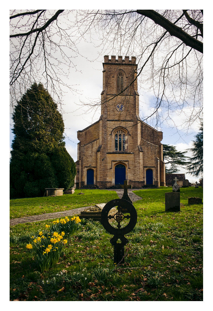
Opposite number 36 we got our first sight of our goal – the Church of St Mary, even though we were now right on top of it. The church really has been shoe-horned into its tiny plot which meant that it was completely impossible to get a photograph of the whole building. Even from a distance looking down into the village the little steeple of the church hides itself away. Unless you knew it was there you wouldn’t notice it.


St Mary’s is a chapel of ease, a subsidiary to St Margaret’s at Corsley. It was built in 1902-03 by W.H. Stanley in the Arts and Crafts Gothic style and was largely funded from £10,000 left in the will of Mary Barton of Corsley House when she died in 1899.

I loved the clean lines and simple architectural touches in the church. The early afternoon light streamed into the church from the south facing windows dappling the pews and the red, blue and yellow floor tiles with patches of sunshine.

There is not really enough level ground outside for a bench otherwise it would have been the perfect secluded place to eat our lunch. So we sat quietly in the pews listening to a tractor working the field on the other side of the hedge close to the church.

Being a subsidiary chapel there is no burial ground at St. Mary’s, the deceased being carried to St Margaret’s for burial. When seen from the summit of Cley Hill it looks no great distance from Temple to Corsley so it seemed an extravagance to build a chapel of ease so close. But the Barton family presumably wanted to leave a legacy and a very fine legacy it is. Sadly the church is now redundant with just the occasional service, but is carefully looked after by the Friends of Friendless Churches. There are two organs but the one played by Ben Maton is by the chancel with the organ pipes above it.

Eventually we re-traced our steps the 50 metres or so to the crossroads by the triangle of grass in the centre of the village. In the distance to our right we could see that the lane led to a large house on the hill. This was the aforementioned Sturford Mead which was built in around 1820 for a Mr Fussell. I’ve not been able to find out anything about Fussell but it is an old Wiltshire name. The house is on the market at the moment for £4.25m apparently!

We continued back past Lavender Lodge to a footpath into fields on the right. We climbed the slope then on towards the unnamed farm buildings over the brow of the hill. I looked behind for a shot of St Mary’s but still all I could see was the top of the tower. I think the only decent photograph of the whole church and its setting would be from a drone, and indeed in the church there was fantastic book of photographs that included an aerial shot of St Mary's. We followed the footpath signs through the farm which I think was a livery stables, then on across the fields back towards the A362. Here we had to make another precarious crossing of the road, this time to the wide verge in front of Sturford Mead Farm. I stopped to photograph the spring crocuses in front of the sign but the traffic was noisy and fast so I was keen to get on. Fortunately it wasn’t far until the verge led us to a footpath on the right.

Behind the farm buildings we followed the line of the footpath due east across fields to the flanks of Cley Hill looming high above. Reaching the gate in the fence line we searched for the best route up. If you look at the contours of the map you will see that the side of the hill is very steep but we decided on a direct ascent to the trig point. I have to say it was tough going and at times we were on all fours. We zig zagged as best we could to ease the gradient but there was no escaping it. You could of course avoid climbing the hill completely and being on open access land you could just follow the base of the hill round to the path leading back to the car park. But then you would miss those incredible views from the top.
Eventually the gradient reduced and we tracked round one of the Bronze Age barrows to approach the trig point. Cley Hill is one of those places where you wonder how archaeologists make any sense of it. Here you will find a large Iron Age univallate hillfort; two late Neolithic/Bronze Age bowl barrows; two flights of medieval strip lynchets; a cross dyke; and an 18th century chalk quarry. Colt Hoare and Cunnington excavated here in the 18th/19th century and without the techniques of modern archaeology I wonder what they made of it? But with millennia of human occupation and use is it any wonder that Cley Hill has such mystical powers, certainly for earthlings and maybe even for beings of other worlds?

With 360 degree views of Wiltshire and on into Somerset the vista is stupendous and worth every moment of the climb. It was by now a beautiful warm spring day, and several other people were enjoying the moment on the hill. I stood by the trig point for a long time waiting to get a photograph without people. A woman walked slowly across the plateau with her son and dog until they were directly in front of me as I stood holding my camera waiting to get a photograph. They stood no more than about five metres in front of me for a good five minutes so I decided to make use of them for the photograph! I assumed she wouldn’t mind as she stood there for so long. But hey, why not? They were enjoying the scenery just as we were. Anyway, in hindsight I was quite happy to have the woman and child in my photograph on Cley Hill.


Finally it was time to leave before we got caught up in rush hour traffic. Descending the hill was almost as challenging as climbing it. It is hard on old knees. There are plenty of well worn tracks but of course after the rain they were a little slippery in places. We were soon on level ground and the track that led back to the car park which was by now almost full. We had walked just over 10 kms/6.34 miles. Most of it was easy going with lots of it on level ground. Yes it was muddy in places but only because of the protracted rain. But be warned the climb up and down Cley Hill is tough so you may want to miss this out if you are uncertain.

Route map in OS Maps App:

Comments