
The Curse of the Inaccessible Monuments
- Paul Timlett

- Jan 11
- 16 min read
Updated: Jan 30

Anyone who has read any of my Hidden Wiltshire blogs will know that I love a rant. However, whilst supping a pint during the course of this walk, my regular walking buddy and neighbour Stu suggested to me that people just want to read about the walks we do, not read a rant from some miserable old bloke. Like any good friend I always listen to Stu’s advice – then ignore it. So buckle up.
I’ve long wanted to visit Windmill Hill, which is just a couple of miles from Avebury. But somehow I’ve always got distracted. So on this occasion I planned a route that would start with it. Whilst I studied the map, trying to connect up other nearby places I wanted to see by means of England’s non-sensical public rights of way network, I spotted three further features that I knew nothing about which probably qualifies them as “hidden”. So in the space of 8 miles/13 kms this walk includes a Neolithic causewayed enclosure, a little known stone circle, a windmill mound, three Medieval churches, (a pub), and the site of an abandoned Medieval village. It was a lot to cram in during the short daylight hours available to us.
Right from the off we were presented with a problem. Parking. We wanted to start the walk with Windmill Hill before heading north. As ever I head to a church as parking can often be found nearby. I’d checked Google Streetview and there seemed to be two or three parking spaces by the Church of St Mary Magdalen in Winterbourne Monkton. There was a sign saying that parking was for the church and that overnight parking was not allowed. Since we were visiting the church, as well as two further churches, we thought that would be OK. However, next to the church is a large modern village hall with a big car park so we thought we’d check that out too. As we walked up to the hall someone emerged. We asked if it would be possible to park in the large (empty) car park. He replied “Not unless you want to be locked in”! We asked if there was anywhere else we could park in the village to which he simply replied “No”. The lanes through the village are narrow and the verges and every other bit of open space were littered with “Private” or “No Parking” signs. The chap at the hall then asked what we were doing. I replied that we were going on a walk to the three churches in the area to which he replied that we could park by the church as long as we didn’t park overnight! I said that we’d be out all day but he offered to tell anyone who asked that we were visiting the church – which we were.
Whilst we were able to leave the car in the little parking area up the lane just beyond the church I’d suggest that you begin this walk in Winterbourne Bassett. I’ll explain more later. But for the purposes of this blog I’ll relate the story of the day just as we experienced it, starting at the Church of St Mary Magdalen in Winterbourne Monkton.
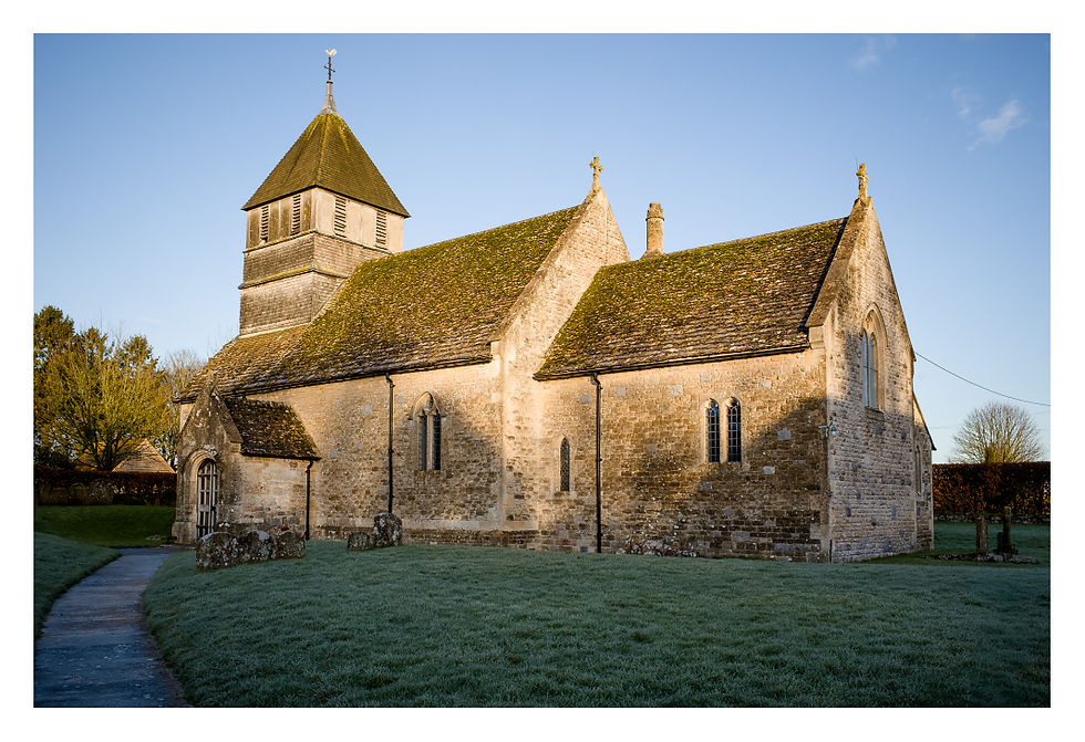
The thing that strikes you first about the church is its squat three stage square tower topped by a pyramidal roof. And the chimney at the eastern end of the nave! I’ve never seen a church with a chimney before. I assume this was installed during its Victorian restoration in 1877-9 by William Butterfield – I guess the Victorians were a bit soft compared to their Medieval ancestors so they installed heating? Although little of the church’s Medieval origins remain. But this was a sacred place before the original church was built in the 13th – 14th centuries and monks from Glastonbury used to meet here for worship in the 10th century.


As always the font is the oldest surviving object, this one dating from the 12th century. Reflecting the area in which this church is found, in the churchyard at the eastern end of the church by the path leading from the little car park can be found a capstone from a local burial mound perhaps covering a grave.

From the church we returned to the lane and walked south past the village hall then followed the lane east back towards the A4361. At the little bridge over the River Kennet we turned south along the public footpath that follows the line of the river. Coming to a small belt of trees the path passes through a gate to cross the farm road and turns south again. Soon the footpath meets the White Horse Trail where we turned right and headed west towards Windmill Hill which the finger post suggested was a mile away. I would say it was more like a kilometre.

It’s not long before the first of the many burial mounds on and surrounding Windmill Hill comes into view as the route climbs gently towards it. It’s only when you get to the gate by the summit that you realise that this Neolithic causewayed enclosure does indeed command the heights, looking down as it does upon the valley of the Kennet and beyond to Silbury Hill and the distant hills above the Pewsey Vale. Reaching the summit a flock of Lapwings flew over our heads making the “peewit” sound that gives them their folk name. Fully exposed to the biting wind it was bitterly cold up here, so excuse my sniffing in this video!
Windmill Hill is the largest Neolithic causewayed enclosure in the British Isles. It was built around 3675 BCE, some 1200 years before its more famous neighbour – the ancient monument at Avebury. Whilst early on this cold frosty morning in January I’ve little doubt that Avebury was already busy with visitors. We had Windmill Hill to ourselves.
Even before the enclosure was built there is evidence of a prehistoric field system here. The site consists of three concentric but intermittent ditches and a small mortuary enclosure “where human corpses were left to be picked clean of flesh prior to the ritual interment of the skull and principal bones in a chambered tomb such as that of West Kennet nearby” (English Heritage). It was largely abandoned by around 2500 BCE but was later used in the Bronze Age. There is a group of eight Bronze Age round barrows forming the core of a wider round barrow cemetery of 19 barrows in total. Animal bones were found here indicating feasting, animal trading or rituals, but pottery and human bones were also found including an intact skeleton of a child. In the 1920s Marconi planned to build a wireless relay station on the site so Scottish Archaeologist Alexander Keiller bought it, and over the years he conducted many digs on the site. Heir to the marmalade empire, this is the same Alexander Keiller who also bought Avebury.
You get a much better perspective of Windmill Hill from the air. Glyn took his drone there in 2018 so I’ve provided a link to his blog that contains his aerial shots.
Passing through the enclosure heading west we passed one of the best preserved saucer barrows that I’ve seen next to which was a much later boundary stone.

The White Horse Way descends the slopes of the monument quite steeply in a north west direction. On this day the ice made it pretty precarious. At the bottom of the slope by Windmill Hill Plantation the White Horse Way turns left through a gate towards Cherhill Down.

We turned right where the path was now a very muddy byway, even in these frozen conditions. This will be a quagmire in warm wet weather, the track churned up by horses hooves and motor bike tyres. We had to follow this track for around 2.5 kms, although the muddy ruts soon gave way to a better surface, even surfaced with cinders at times. All the while we were accompanied by Goldfinches and Fieldfare.

Ignoring several tracks crossing the byway we eventually came to a T-junction of tracks by some large concrete blocks and next to Yatesbury Withybed. Here we stopped for a welcome coffee to warm us through. The countryside here is flat and open. Already freezing cold under the clear blue sky, the biting wind blew uninterrupted across what looks like a prairie. We were glad of all the layers we had packed for this walk.
Feeling a little warmer we turned right at the junction along the cinder covered byway that had come up from Yatesbury. After around a kilometre we came upon the large drying sheds at Whyr Farm. Next to it was a modern farm cottage - Elm Tree House. A modern house, the location was idyllic gazing as it does across open fields without another house in sight. The swing seat in the front garden must be the perfect spot for a glass of wine on a warm summer’s evening. I have since been told by a local that Whyr Farmhouse itself is a lovely 19th century house to the south, not visible from the route we took. But if you want to see it for yourself and have more time there is a footpath from Elm Tree House to Whyr Farm which would involve walking out and back to it - a total additional distance of about 500 metres.

The track past the farm then becomes a tarmacked road even though it leads nowhere but the farm. This road must have cost the farm a fortune to lay, assuming it is unadopted and not funded by the council? We continued along it for another 1.5 kms until we reached a crossroads by which stood a large sarsen stone. Here the road meets the minor road between Winterbourne Bassett and Clyffe Pypard. And this where I was going to begin my rant. But read on!

Opposite the junction lies something that caught my eye when planning this walk. A stone circle. One which I knew nothing about. I did some research using the name on the OS Map – Lambourne Ground. All I could find was the Historic England entry showing the stone circle as a scheduled monument. It references the fact that a concentric circle was identified by Stukeley in 1793 (athough as someone pointed out to me this date cannot be right since Stukeley died in 1765) “… and consisted of an outer circle of up to 71m in diameter, an inner circle of 45m and a single central stone”. Further stones were recorded in a survey by Smith in 1881-2. “… and in 1998 a Geophysical survey was carried out. It confirmed at least seven of the stones as indicated by the Smith plan had survived as either visible stones, buried stones or anomalies thought to represent socket holes, and the latter survey indicated more ‘anomalies’ than previously known and also a drain or wall surviving as a buried feature. However, neither survey was able to produce the full plan of the concentric circle”. (Historic England). The evidence from Stukeley and Smith was enough for the site to be designated a scheduled monument in 1924, which it remains to this day.

And this was to be the reason for my rant. The stones, three of which we could clearly see in the field, were on land surrounded by fence and hedge. There was no access to the public and the field looked as though it is just used to exercise horses. So we stood and cursed the fact that here was a scheduled ancient monument, something of great significance to the nation, to which the public were denied access. However, in writing this blog I did some more digging (pun intended). And it seems that there are question marks over whether this is a stone circle at all or just a collection of naturally occurring sarsens. A research paper published in The Wiltshire Archaeological and Natural History Magazine in 2003 casts doubt on the matter. It suggests that whilst there seems little doubt there is a stone circle in the area it is not in this field. Stukeley made a detailed drawing of what he found but many have suggested that his survey and drawing has been misinterpreted and that the site of the stone circle may be in the field to the south of the lane. Further investigation is required.
Denied access to what we were reliably informed was a scheduled monument we turned east along the lane towards Winterbourne Bassett in a search for another scheduled monument about 300 metres along the lane. The Historic England website shows something called Winterbourne Bassett Mound right next to the road. This is the site of a post mill – a Medieval form of windmill. But there was a high bank and thick hedge between us and the mound, again with no public access. It could not be seen from the road. I went back up the lane a little way to where the bank was not so high and crawled through the hedge only to find a barbed wire fence. But I could make out the mound. Not much to see perhaps but a scheduled monument to which the public is denied access all the same, something that should be considered against the fact that an estimated 28% of scheduled monuments in England are not accessible to us. A figure that is very likely a significant underestimate. In Medieval times there would have been a “wooden superstructure rotated about a central vertical post. The central post was mounted on cross timbers which were stabilised by being set into a mound” (Historic England). Of course the wooden structure has long since rotted leaving an unassuming lump in a field.

As part of an investigation prior to some new building in the area Wessex Archaeology mentions that Winterbourne Bassett mound was a prehistoric funerary monument although the report also references the Historic England listing which says it's a post mill. In speaking to a local resident I was told that the mill powered a foundary that once stood there.
Continuing our walk along what was now the High Street we came across a pair of delightful thatched cottages which are also listed by Historic England. These are 18th/19th century brick and sarsen buildings, the sarsens having been sourced from the local area. They may even have been plundered from the elusive stone circle up the road. But I loved the way what I think was pyracantha had been allowed to grow around the door of number 20. I could almost picture a hobbit emerging from within.

We were now heading for the church in Winterbourne Bassett. After our sub-optimal experience of parking in Winterbourne Monkton we were also on the lookout for somewhere better to park (and therefore begin the walk). The High Street in Winterbourne Bassett is plenty wide enough to park but something else caught our eye at the end of the village. A pub. And it was open! Stu and I are completely incapable of passing an open pub on our walks. Despite being short of daylight hours we convinced ourselves that we had time for a quick pint so in we went.

The Winterbourne was a real treat. We both like our real ales and it was heartening to see that they had just one beer on despite having four hand pumps. At this time of year most country pubs don’t have the turnover to warrant any more than one beer as it quickly goes off. So here was a landlord who knew what they were doing. The pub was immaculate whilst being warm and welcoming. The food looked amazing, especially the fish and chips. Next door is a large car park so we had an idea – how would the landlord feel about people parking there for the day whilst they walked, on the understanding that they would pop into the pub afterwards? So I went up to the bar and asked the woman serving if she was the manager, to which she replied “Sort of”! She explained that The Winterbourne is a community pub ie it is owned by the community. She was a tenant of the community and had been brought in to manage the pub. I asked about parking and without hesitation she agreed that I could mention in this blog that they welcome walkers (there was a group in whilst we were there) and that as long as people phoned ahead to ask if they could park she would have no problem as long as they came into the pub at some point on their walk. I suggested that any Hidden Wiltshire reader doing this walk would likely be out all day and that they might arrive before the pub opens. She said that she lives on the premises but if there is no answer to just leave a phone message.
So my whole hearted recommendation is to start this walk from Winterbourne Bassett and, if you can, support the pub in return for which you can use the car park. Below is a link to their website but the number to call is 01793 731257. I forgot to ask the manager her name but she was delightful and if she reads this I would like to say that the business she has built is a fantastic example of how good a community pub can be. The staff were super-efficient and friendly and there were at least two chefs in the kitchen on this Wednesday lunchtime in January so you won’t have to wait long if you’re on a mission. It brands itself more as a restaurant but don’t let that put you off if you just fancy a pint – they are more than happy if that’s all you want.
They also have a Facebook page.
Warmed through from a tasty pint of London Pride we walked the short distance to the bridge over the Kennet and turned right up the drive towards the church. Before turning right again to the church you will find on the turn the splendid late 18th century Manor House.

On the apex of the bend was another driveway to The Old Rectory but this was not visible and it’s not listed by Historic England. The sun was getting low now despite it being only 2:30pm. As we approached St Katherine and St Peter’s church one side was in deep shadow, but as we rounded the building to the south porch of this lovely 14th century building it was bathed in the warm glow of the winter’s afternoon sun.

Once inside the church the feature that caught my eye was the early 13th century font. Again we find this is the oldest feature which pre-dates the building itself. I often wonder why this is the case. Clearly the font was brought from elsewhere. Was there a reclamation yard somewhere in Britain full of fonts? Did the 14th century builders go and select a suitable model to instal in the new church? Next time you are in a Medieval church have a look at the font. It is almost certainly going to be older than the church itself. But the most notable feature of this church is the limestone grave slab effigy from the late 13thcentury with a man and woman holding hands below a trefoiled canopy. Except I completely forgot to look for this so I don’t have a photograph to show you! One day I’ll go back to see it.


Leaving the churchyard by its southern gate (next to which you will find a public toilet and the notice in the photograph) we headed towards the early 17th century Rabson Manor, although you can’t really see much of it from the public footpath.
In front of us the footpath passes through equestrian yards. It was all a bit confusing and the public right of way has been moved but if you follow the route map below and aim for the next point of interest, the Medieval Village of Richardson, you will be fine.

This was another place on this route I’d never heard of. The village, long since abandoned, dates to at least 1242 when it was referred to as Ricardestone, and in 1377 there were 31 poll tax payers. It survives as a series of low rectangular building platforms, enclosures and trackways located either side of an east to west orientated hollow way which led to a fording point across the river.

The village was largely abandoned by 1545 but the hollow way, which would have been the main thoroughfare through the settlement, remained in use as late as 1773 before being abandoned by 1844. The layout of the village is still very prominent on the ground but I’d love to see some drone footage as ground level photographs don’t do it justice. The Historic England entry does include a couple of aerial shots which provide a great viewpoint. This is one of the better preserved abandoned Medieval villages that I have seen. Here’s a short video I recorded.
We were now on the penultimate leg of our journey, this section towards Berwick Bassett - somewhere I was keen to visit. It was only a few hundred metres across the fields until we reached the wonderful church of St Nicholas.

This parish church traces its origins to the 15th century but was restored in 1857 by prolific Victorian church restorer T.H. Wyatt who we have come across many times in these blogs. The church is now redundant but has been lovingly cared for by the Churches Conservation Trust.

And yes, the 13th century octagonal font with trefoiled panels pre-dates the church. Another trip to the reclamation yard!

I first came across this church just a few weeks ago when the ridiculously talented Andrew Rumsey, sometime Hidden Wiltshire follower and Bishop of Ramsbury, recorded one of his delightful short videos in here the day before Christmas Eve. Here is a link to the video and his haunting rendition of an old folk carol set to an arrangement by Vaughan Williams. I first listened to this as I walked alone in the fading early evening light on Salisbury Plain minutes after Andrew published his video on YouTube. He subsequently told me this was the best place to listen to it!
St Nicholas is a delightfully simple church and as Andrew points out unusually it still has its original 15th century chancel screen. But as a photographer what really struck me was the light in the church, which it so often does in our Medieval churches. By now we were rapidly losing the light and the way it streamed through the little windows was glorious – probably the only decent photograph I took all day.


In front of the church porch across the churchyard is the lovely late 15th century - early 16th century Tudor Berwick Bassett Manor Farmhouse.

In the south east corner of the churchyard is a little gate that leads down a narrow path enveloped by a mature hedgerow. This leads down to the lane through the hamlet of Berwick Bassett and emerges by the 17th century Berwick Bassett Manor.

We followed the minor road south past Home Farm and Berwick House Farm where the road bends right and westwards. Just after the bend there is a gap in the hedge where there is an almost hidden public footpath sign. This follows the line of the Kennet back towards Winterbourne Monkton. At one point it appears to lead into someone’s garden but as you enter look to your right where you will see a wooden gate on the bank. Go through here into the field and continue south skirting the house and its walled garden.

Soon we saw the church tower at Winterbourne Monkton across the fields in the rapidly fading light. If you stick by the river this will lead you into the village. We turned off the footpath by the pond to take us back to the lane past the church where the car was parked. If you begin the walk at Winterbourne Bassett you should follow the same route (as shown on the map) as it will enable you to visit St Mary Magdalen church.
In all this walk was 13.1 kms/8.1 miles. It was mostly level apart from the gentle climb to and steeper descent from Windmill Hill. Parts of it, particularly between Windmill Hill and Yatesbury Withybed, will be very muddy after prolonged rain. The countryside is mostly flat and open but rewards with expansive views across this historic landscape, whilst avoiding the rampant tourism at Avebury never more than a few miles away.


Thank you! Yes, the drying sheds are part of the farm. As for the farmhouse, yes, there is a drive leading to it which splits into a private drive for the house on the left and the one on the right leads back down south/ southwest towards Berwick Basset.
I hate to be annoying but the Whyr Farmhouse is actually further up the road past the barns and is a rather attractive Tudor house. The other houses you referred to as the farm houses are a more modern fixture as the farm cottages.
What you say about Burberry house or “Hogwarts” as we like to call it due to the flashy lights at night and the adjacent building “Lidl” are, in my opinion, awful redevelopments of an old cottage that a developer has taken control of. He is very unpopular around here!